Category Archives: Public Space

Street spaces over 100 years

For a nice Saturday morning post, David over at Greater Greater Washington points to a great video from San Francisco, circa 1905.  The video is shot from a cable car traveling down Market Street, San Francisco’s great axial street.  The clock tower of the Ferry Building terminates the view, all while pedestrians, horses, cars, streetcars, and just about every other mode of transport share in the controlled chaos of a street where all modes share space.

Our streets weren’t always so compartmentalized, with segregated spaces for cars, pedestrians, bikes, and so on.  David gives a hat tip to the Ludwig von Mises Institute for the video, where the free-market libertarians posting the comments attribute the resulting order to the power of markets to organize themselves.

Several, however, note the limitations of such an example as a case for removing all traffic restrictions and separations – changes in technology, mass, speed, and so on – as well as the fact that managed and planned order can indeed be more efficient than this type of organic order.  Another notes that some of the chaos may not have been completely authentic:

I saw this video before, with a commentator talking alongside it. The car that crosses the tracks and is barely missed by the streetcar is actually part of the filming team, asked to do that to keep things interesting. If you pay attention, you see him cutting accross [sic] many times, actually crisscrossing in front of the streetcar.

Yet another commenter points to an almost exact re-creation of the same video from 2005, this time making use of travel along the F-Market streetcar line.

The arrangement of street space, obviously, has changed.  So has San Francisco’s urban fabric, now complete with skyscrapers.  The older video just predates the devastating 1906 earthquake and fire, a major factor in re-shaping San Francisco’s urban form.  The comparison between the two is stark, both for the things that have changed, as well as for the things that have not.

Back at GGW, commenter Lance throws a few barbs about overhead wires obstructing vistas.  It’s worth noting that DC’s current streetcar plan does not have any long stretches of track along the main vista avenues, such as Pennsylvania Ave.  Under the idea of a hybrid solution and careful routing, we might not even need wires to cross those main vistas, yet alone run along them. It’s also worth noting that San Francisco’s wires in the 2005 video are not just for streetcars, but also electric trolley buses – a few of them are seen in the video itself.  Since trolley buses do not run on steel rails, they require two wires to act as a ground.

Miscellany

Basic Training

The Tsarchitect had a great reminder on the importance of the basics today – linking to a video from William Whyte, from a video version of his great work, the Social Life of Small Urban Spaces.

Part 1:

The remaining sections of the video are available here: (onetwothreefourfivesix)

I hadn’t watched the video since graduate school – thanks for the reminder.  It’s well worth a viewing.

NCPC Items

A couple of items related to the National Capital Planning Commission:

JDLand had an item a while back about their largely favorable reaction to the 11th Street Bridges project – with the exception of the streetcars, of course.

However, they are not at all happy with DDOT’s decision to choose a streetcar system with overhead wires, and the document goes into detail on how this works against federal interests, as well as listing what non-overhead-wire streetcar options exist out there (none in the US so far). Their conclusions (page 22):

“Recommends that DDOT not include streetcar system components for overhead wires as part of the 11th Street Bridge project and that DDOT prepare an environmental impact statement for its proposed District wide streetcar system that examines potential impacts on the L’Enfant City and Georgetown and that includes an analysis of propulsion systems that do not require the use of overhead wires.

“Advises DDOT that the Commission does not support a streetcar system with overhead wires because it supports the unobstructed views to important landmarks along the city’s streets and avenues that are integral to the District’s unique character and result from the long-standing federal statutory prohibition against using overhead wires in Washington City (the L’Enfant City) and Georgetown.

“Encourages DDOT to pursue alternative propulsion technologies for the proposed streetcar system that do not require overhead wires in accordance with its January 24, 2008 commitment to include dual vehicle propulsion requirements in a solicitation package for the development and implementation of the broader streetcar system beyond the Anacostia and H Street/Benning Road corridors.”

Meanwhile, at GGW, Matt Johnson has a post up on potential freight rail bypasses of DC, triggered in part by safety concerns, and in part by the NCPC’s desire to remove the current rail rights of way though the District.

These aesthetic concerns shouldn’t be underestimated, but from my perspective, the minimal obstruction of streetcar wires isn’t worth the kind of opposition the NCPC is putting up.  Even if you take wires as a negative (which I do not think is a given), the net results are certainly a positive for DC.

Shopping Spree

Transit Miami reminds us all of a post from the Infrastructurist back in May with a nice comparative chart of transit costs by mode, with references to specific projects.

Modernism in DC

DC MUD had a great interview with architect Ali Honarkar (designer of the Lacey) with some great tidbits on DC’s style, height limits, and NIMBYs:

DCMud: Lacey has gotten attention inside DC, but also outside DC. What do you attribute that to?

AH:
Yeah, I don’t know! (laughs). We designed it to get attention, that’s what you do. We’re not going to write a hit song and apologize, you want it to be played. Actually we’re getting more national than local attention. I’m a little disappointed with the local media, and I think it may be driven by sponsors, this very conservative southern town. You would think the Washington Post, as local media, should know what’s going on around here. We’ve seen the Lacey in New York blogs, LA blogs, and architecture blogs, and I’m always amazed how they find us. But they don’t have to find you here, we’re here, they should know what’s in their back yard.

On sustainable design:

DCMud: So green is not cheap, design is not cheap, how do you combine those two goods, and still make it affordable?

AH:
Its hard, there are metropolitan cities, like NY would be the first, Chicago, San Francisco, LA, they have that. You put up a building anywhere in New York, they will still line up if its good. I think the DC culture, within the last 10 years has really changed, you see a lot more emphasis, not just on housing, but the restaurants, you see a lot more design, restaurants, bars, we’re getting there slowly but surely. We’re not very good at that, we just do it. There were so many ways to make the Lacy cheaper. But at the end of the day, the architect, the developer, have to be able to look back and be okay with it. The average life of a building is 25-30 years, we’d like to see the building there in a 100 years. Real estate is a long-term thing; we don’t do things for marketing purposes. With the whole green movement, nobody ever uses bad materials on purpose. Another way the AIA is using – you know when the record companies stopped using vinyl because it was no good – the same with the AIA, we achieved it in the Lacey, we’re doing it in a small residential project, you put a good project out there, people will follow.

On height limits and NIMBYs:

DCMud: Height restrictions and historic preservation?

AH:
It’s partly that, but, no offense to attorneys, you do any work in DC, forget the ANC and historic preservation, but every other neighbor is an attorney. Its great to have pride in where you live, but people feel like they get to claim it, we see that all the time, we always feel like we don’t want to deal with it any more, but then we get a good client, who wants to do something different, and we say, okay, lets do this again. Its not historic preservation, I think its more the people in the neighborhoods that want to stop the process.

DCMud:
Do you think the height limits are a good thing?


AH:
I like them; I think you are most creative when you are challenged. DC is my favorite city, and you have New York for that. London, Paris, the scale is completely different, most European cities are like that. I like the height restriction where it is, we should just be a little more creative. We have suburbs to balance stuff out.


DC's odd-shaped public spaces needn't be awkward or neglected

Longfellow Monument.  Photo by NCinDC on Flickr.

Longfellow Monument. Photo by NCinDC on Flickr.

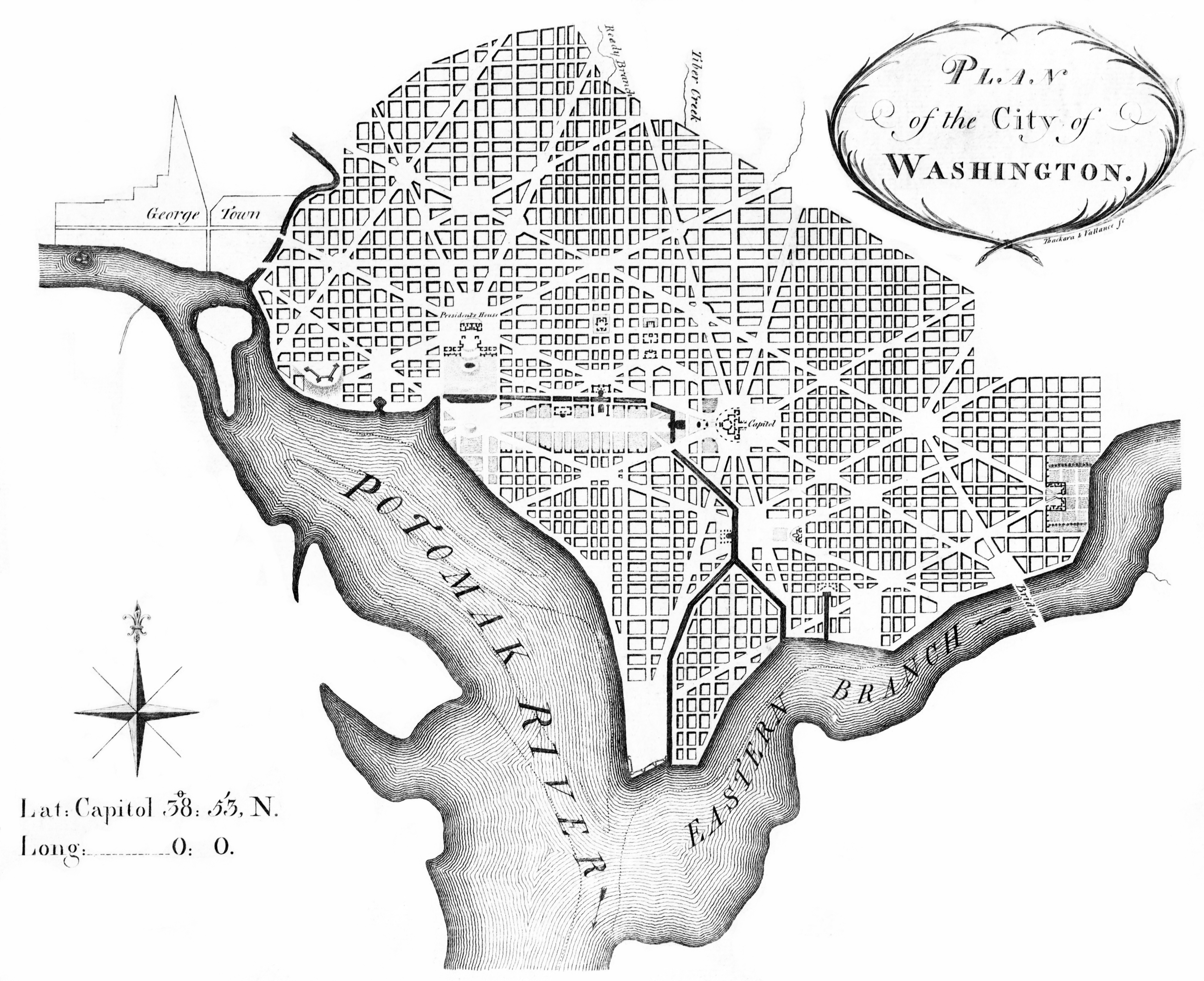
In terms of urban design, Washington DC is unique amongst American cities.   Between the height limit and the monumental core, DC’s plan is befitting of a national capital.   Grand avenues, civic spaces, and prominent monuments.  L’Enfant’s grand plan was not just for the nation, but for the local community as well.  Too often, however, many of the interesting local spaces created by that grand plan have been taken over by cars, fallen into neglect, or both.

Despite its grandeur, the L’Enfant plan isn’t universally loved.  Matt Yglesias takes issues with DC’s “triangles of doom,” while citing Bostonian Noah Kazis’ learned love for DC’s grid and avenues over Boston’s colonial mishmash of streets.  Yglesias notes:

I think there’s definitely something charming about metro Boston’s tangled web of streets. And there’s clearly also something good and practical about a regular grid. But I really don’t think there’s any case at all for what we’ve done in DC in terms of super-imposing diagonal boulevards on a basically rectilinear grid.

Yglesias touches on three major aspects of city design – the “organic” pattern, the grid, and the diagonal.  “Organic” networks, such as Boston, are really not organic so much as they are unplanned.  This is not always the case, as there are plenty of planned cities designed to look like “organic” street networks.

DC, on the other hand, is clearly a planned city, at least within the confines of the L’Enfant Plan.  Outside of the L’Enfant city, Adams Morgan exhibits plenty of “organic” patterns – but the iconic streetscape for Washington is definitely L’Enfant’s radial avenues superimposed on a rectilinear grid.

What Yglesias misses, however, is clear case for DC’s avenues.  We can never forget that Washington, DC is not just a city, but the capital of the United States – and the urban design of the city reflects that fact.  Spiro Kostof, in his book The City Shaped – Urban Patterns and Meanings Through History, calls this kind of capital monumentality “the Grand Manner.”  The Grand Manner, Kostof writes, “is not the currency of little towns.”  Indeed, in his chapter on the Grand Manner, an aerial photo of Washington, DC occupies the entire initial page. These are not supposed to be purely functional streets, though Daniel Burnham and other practitioners of the City Beautiful would argue they are helpful.

DC’s diagonal avenues are an important element of this grand aesthetic.  They provide vistas to key buildings and monuments, and though they are geometric in plan, they also respond to key travel patterns in the region (such as Connecticut Avenue and New York Avenue).  These diagonal streets are also not unique to Washington, as Chicago, Detroit, and others have important diagonal streets superimposed across urban grids.  In modern function, streets such as Broadway in New York predate the grids they bisect, but nevertheless function in similar ways today.

Even ignoring the political implications of such streetscapes, the creation of small triangles, nooks, and crannies within the grid should be seen as a positive.  From the national perspective, these were seen as locations for monuments.  From the local perspective, L’Enfant (and later Ellicott) ensured a public circle or square to serve as the focus for each section of the city. Likewise, the radial avenues connect these parts of the city to each other with both direct lines of communication and transportation.

However, Yglesias isn’t convinced.  He notes this kind of planning “leads to lots of very weird intersections.”  As an example, he cites the intersection of New York Avenue, H St, and 13th Street NW as a confusing intersection for drivers and pedestrians alike.  Tellingly, Yglesias uses a Google Maps image to illustrate this.

The Google map, however, focuses on the auto circulation routes – not the public space.  When looking at either the L’Enfant Plan or the Ellicott Plan, neither of them delineates traffic lanes or vehicular circulation.  Instead, those plans focus on defining the street as a public space.  Likewise, most of DC’s circles and squares are defined not by the traffic patterns of the streets, but by the blocks that surround them.

L'Enfant Plan_detail

Detail of the L’Enfant Plan.  Note the lack of design within the public squares.

The awkward intersections of auto traffic are a relatively recent occurrence, not a hallmark of the plan.  Yglesias understands this, at least at an intutive level, since he made a great suggestion several days later about improving traffic and pedestrian space within one of L’Enfant’s many squares.  These kind of discussions are not new to DC, as many squares from L’Enfant’s plan do not function as squares at all.  Traffic bisects them – at Eastern Market and Potomac Avenue for example, proposed changes would open up these spaces.

Likewise, there are many triangles and small parks at the intersections of DC’s radial avenues and the grid.  Some house interesting public spaces, while others are substantially underutilized.  Since we have them, it’s up to DC to make use of these small spaces.  Yglesias notes:

But worst of all they create these horrible dead spaces when the wedges between the various streets are too small to put a city block on. Every once in a while this process results in a “triangle park” that’s actually nice and used for something (the part at 1st, R, and Florida has nice synergy with Big Bear Cafe and the Bloomingdale Farmer’s Market) but the typical triangle park isn’t really used for anything and many of them scarcely deserve to be called parks.

Green space and public space are good things, but they’re really only good if the spaces are usable and used in practice by the people who live and work in the area. That requires them to be located and sized for real reasons (”this would be a good place for a park”) and not just used to fill up awkward gaps in a street grid.

Indeed, many of these triangles are underutilized.  However, this is a problem of programming, not of design.  Kostof notes in a video of a 1991 lecture series accompanying his book that L’Enfant’s plan specifically avoided those cast-off spaces Yglesias worries about – each public square was to be programmed as a focus for a neighborhood.  They were not just used to fill in the gaps of the street grid, and they need not be treated as such today.

Instead, the challenge is to re-program these spaces, as exemplified by the Bloomingdale Farmer’s Market.   Not every space needs to be active or monumental, but there are plenty of opportunities to improve and enhance DC’s public spaces.

(Cross-posted at Greater Greater Washington)