Category Archives: Commuter Rail

Transit Expansion

Photo by matthewbradley

Streetcars

We’ve got more details on DC’s streetcar plans.  BeyondDC has more details on the plans (at BDC/GGW), and Yonah Freemark chimes in with comments at the transport politic.

And, just for fun, this is a great reason to link to the old map of DC’s streetcar system circa 1958 (matching many of DDOT’s historical photos).

Metro Extensions

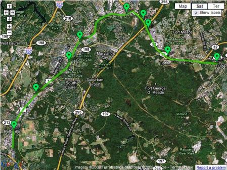
In other transit expansion news, Prince George’s County is working on re-doing their transportation plan.  One of the ideas thrown out so far is an extension of the Green Line from Greenbelt through to Laurel:

The county also wants the Green Line extended from Greenbelt to Fort Meade by way of Beltsville and Laurel. The stops could include Konterra, a massive mixed-use development underway at the eastern end of the ICC.

GGW’s summary on these developments also links back to previous posts on the plan’s highway and transit components.  Dave Murphy, however, takes the Green Line extension idea and improves upon it – by diverting the Metro extension away from the CSX/MARC Camden line tracks though Fort Meade (which is already a huge employment center and set to grow even more with various BRAC relocations) before terminating at Odenton – also connecting with the MARC Penn Line.

GreenLineExtMap

The idea of serving Fort Meade is good – it needs more transit service to meet growing demand.  Likewise, the idea of connecting both MARC lines together through Fort Meade is also good.  The problem, however, is that Metro isn’t the best tool to accomplish this task.  It’s the most expensive mode of transit we have in this region – and should be reserved for the highest capacity, highest potential routes.

The desire to extend Metro rather than invest in other modes is understandable – everyone wants the best.  However, in this case, a massive upgrade of MARC service would be more appropriate and cost-effective – expanding service days and hours, increasing frequencies, offering through-routing to Virginia, and so on.  This site has the advantage of MARC lines on both sides.  If service levels could be increased to match those on some of the Metro-North commuter lines (10-20 minute peak hour headways, late night service, weekend service), extending the Metro wouldn’t be needed.  In the comments of the GGW article, BeyondDC provides an alternate proposal – increasing MARC service while building a cross-“town” light rail line to provide service through Fort Meade.

These kinds of ideas, whether they’re fantasy maps or some other proposal, always generate a lot of interest.  Matt Yglesias offers his thoughts:

Here I think the key thing to keep in mind is that when you’re talking about new heavy rail construction, the potential benefits can be quite large but you have to decide if you actually want to seize them.

If you added a Metro station there, would the local area permit the surrounding quarter mile or so developed as a fairly dense walkable community? Or would people hear about proposals to build on the green space and up-zone the built-up area and decide that would lead to too much traffic? Maybe instead they’ll want to just turn the undeveloped patch into another parking lot. That’d be no good. And the existing land use patterns around Maryland’s Green Line stations don’t inspire a ton of confidence.

Of course, it’s much easier to create an urban environment in an urban setting – plus, you can create the same kind of TOD/urbanism with a heavily accentuated MARC service.

Ryan Avent also chimes in at The Bellows:

To expand on this a little bit, Metro is the region’s most expensive transit option, but it’s also the one with the greatest potential to drive development. Generally speaking, we want to plan our transit systems so that we’re maximizing the benefits we get for the cost of the investment. If Maryland isn’t prepared to zone for significant development around Metro stations, it would be very silly to make the large investment in Metro. Better to develop a commuter rail line or light rail line or both (depending on anticipated development and commuting patterns).

Metro can indeed help shape development, but it’s important to realize that Laurel is still Laurel – no matter how you slice it, it’s a long ways away from downtown DC.

The Silver Line, to take another example, is an expensive investment. It would probably have been much smarter to simply connect Fairfax County destinations (and Dulles) with Arlington and the District via commuter rail but for the fact that the new Metro line is part of a major effort to increase density at Tysons corner.

The key difference between a Green line extension and the Silver line, however, is that the Green line already parallels an existing transitway with huge potential to upgrade service on the cheap (relatively speaking).  The Silver line doesn’t have a similar option – Commuter Rail beyond Tysons Corner would indeed be a great option in the abstract, but the conditions don’t exist to make it work.

Avent’s conclusion is spot on, however.  Extending Metro further out along the Green line is a mis-match between location and mode, and these kinds of mis-matches will impose costs on the core.  Instead of a Parisian system where the Metro and RER compliment each other, Metro’s hybrid nature pushes these two uses into the same system.

These costs are increasingly borne by users in the core of the system, where growth in the number of trains and passengers have led to crowded conditions on platforms and back-ups during peak periods. To some extent, this can be addressed by increasing peak fares, but given the obvious value of Metro, the growth in the system’s spokes, and the fact that the District is better suited than almost anywhere else in the metro area to handle increased density, it seems clear that new core capacity is needed (as well as a new river crossing over or under the Potomac).

Metro doesn’t stop running when it enters the District. If Virginia and Maryland want to continue to build Metro extensions, they ought to offer their full support to an effort to add capacity in the core.

What’s more – investments in the core (say, in the form of a new, separated Blue line) will bear fruit for lines outside the core as well.  The new Blue line would eliminate the capacity constraints of the interlined portion of track through DC – thus increasing the potential capacity on existing Orange and Blue line track in MD and VA.

Minneapolis – Transit plans

A few more items from my trip to Minneapolis. The Twin Cities have some big plans for transit improvements.

Under construction now is the Northstar Commuter Rail line, as well as the concurrent 2-block extension of the Hiawatha LRT to meet the commuter rail station.   The new station would be a potential hub of multiple light rail lines, as well as the terminus of several commuter rail lines and even intercity high speed rail.  Lofty ambitions, to be sure.

However, at present, it isn’t exactly the second coming of Union Station:

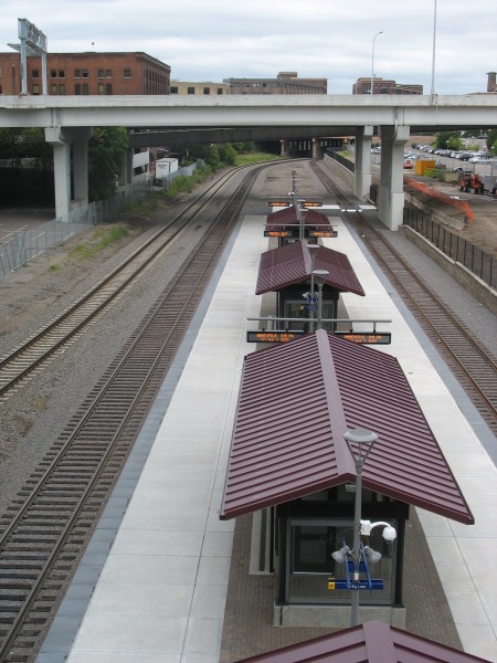
IMG_4476

One platform, two tracks (the third track on the far left is for through freight).  This picture was taken from the 5th Avenue bridge.  The area with the commuter rail platform is in an old rail yard substantially sunken beneath the usual grade for the rest of the area.  All of the cross streets in the area traverse the ditch on viaducts.

IMG_4475

Immediately above the commuter rail platform is the new Ballpark station (that’s Target Field under construction in the background).  The Ballpark will feature vertical circulation for passengers transferring between commuter rail and light rail. The extension of the tracks (as well as the commuter rail) should be operational soon, with the ballpark to open next season.

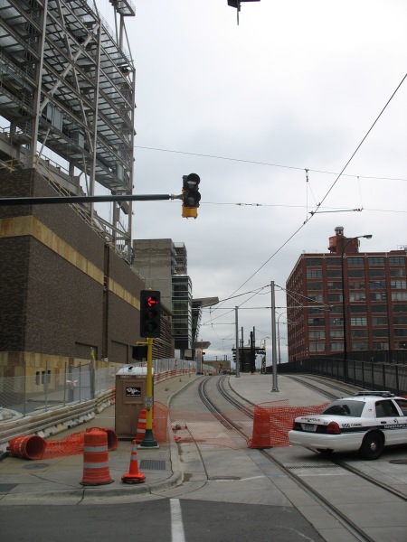
IMG_4471

Right now, only the Hiawatha Line uses these LRT tracks.  Soon, the Central Corridor will join them, offering LRT service to the University of Minnesota and downtown St. Paul.  The next corridor under consideration will be the Southwest Corridor, extending from downtown Minneapolis to suburban Eden Prairie.

Both the Hiawatha and Central lines serve some prominent employment centers, as well as relatively dense neighborhoods and industrial space in need of redevelopment.  The Hiawatha line connects downtown Minneapolis with the airport and the Mall of America.  The Central corridor will extend between the two downtowns, serving the University of Minnesota.

The Southwest line, however, could potentially miss some of the densest, most vibrant areas of Minneapolis in favor of a cheaper alternative routing.  Yonah Freemark analyzes the situation:

After years of study, Minneapolis is almost ready to submit its locally preferred alternative (LPA) corridor to the Federal Transit Administration, which will distribute up to 60% of total funds to the project through the New Starts major capital grant program. In order to receive money from Washington, Metro will have to show that the proposed route meets national cost-effectiveness guidelines, which are stringent enough to sieve out a large percentage of proposed new transit lines.

This requirement puts elected officials in a quandary: should they work to build the most effective transit network possible, or should they limit their ambitions for fear that the federal government will rule out any funding at all?

Effectively, this is where Minneapolis finds itself, and the region is coming dangerously close to eliminating its best route option because of cost-effectiveness concerns. Of the three routes being considered for the Southwest Transitway’s alignment, one (#1A) has been dismissed by suburban officials because it won’t serve the city of Eden Prairie as effectively as the others, even though it would be cheaper to build. Another (#3C) is too expensive because it would require a tunnel under a section of Nicollet Avenue, but it would serve the city of Minneapolis best because it would provide several stations in the dense and active Uptown district. 3C would operate on the Midtown Greenway parallel to Lake Street in that section of the city. The last (#3A) is the only route, according to local planners, that could meet federal cost guidelines — but its effect on the commutes of people who live in Minneapolis would be marginal. 3A would skim the side of the Kenilworth trail and lounge the edge of two lakes, running through neighborhoods of single-family housing.

Yonah created a series of maps showing how the FTA’s cost-effectiveness numbers will likely lead to an inferior project overall.  One picture really shows how absurd the decision might be in deciding the two alignments to enter downtown Minneapolis:

Minneapolis has some promising long term transit plans, but I can’t think of a better example to showcase how misguided the FTA’s cost-effectiveness guidelines are if they favor the green line instead of the blue line on that map.

Polycentricity

VRE Train.  Image from Ouij on Flickr.

VRE Train. Image from Ouij on Flickr.

Nobody would argue with the idea that DC’s commuter rail system could be better.  Metro, however, is largely praised (disaster responses and publicity notwithstanding).  However, Metro also gets attacked in some quarters for its hybrid nature as both an urban subway and a commuter rail system.

Richard Layman in particular likes to emphasize the writings of Steve Belmont.  When talking of transportation, Belmont contrasts monocentric transit systems (essentially dense hub and spoke networks with all lines serving a dense core) with polycentric ones, where the city has many nodes and thus requires many links between them.  Belmont (and Layman) argue that polycentric is bad and monocentric is good – at least at encouraging dense development and urban living within the core.  The problem, however, is that the monocentric/polycentric division isn’t all that useful when only comparing one system to another.

Belmont’s two main criteria for determining the centricity of rail transit systems are station density and the spatial extent of the system.  Metro in DC fails on both accounts, as it has long ‘tail’ lines and stations separated by long distances.  However, within the core, the station density is actually quite high – extremely high when you consider the context and time it was built (as opposed to the older systems in New York et al with predominantly cut and cover construction).

Paris, on the other hand, is the textbook case of monocentric rail transit, Belmont argues.  Paris’s Metro has more line miles than DC’s Metro, but all of them are squeezed into an area no more than 7-8 miles in diameter.  Likewise, there are far more stations within that smaller area.  It’s an incredibly dense system.

Where the comparison breaks down, however, is the limitation in comparing one system to another.  DC’s Metro is a hybrid system and needs to be analyzed as such.  To make it as close to an apples-to-apples comparison, you’d need to analyze a combined system of both Paris’s Metro and RER.

Jarrett Walker did just that.  The end result is that Paris’s employment patterns are far more polycentric (and as Walker argues, more akin to Los Angeles rather than New York) than Belmont might imply. Walker’s starting point was Alon Levy’s proposal for through-running commuter rail trains in New York (Part 1, Part 2), a theme I picked up on with ideas for DC’s commuter rail system.  Walker writes:

But when you start looking at the cost/benefit of all the tunnelling to get the various commuter lines connected to each other, you stumble on an important difference between Paris and New York.  For all the suburbanization of the last 70-some years, New York still has an world-class concentration of jobs and activities in a very compact core (roughly the southern half of Manhattan plus inner Brooklyn).  For trips from the outer suburbs to this core, it’s not hard to get where you’re going with the existing commuter rail line and one connection to the subway.

Paris commutes are widely distributed to major employment centers located mostly on the edges of the city.  This pattern particularly cries out for RER-style through-running of commuter rail because so many people are commuting to a center on the far side of the city from their origin — for example, from suburbs east of Paris to La Défense in the west.  Greater New York would benefit from such an arrangement, but not nearly as much as Paris does.  For New York it’s a nice feature, but for Paris it’s foundational to the growth pattern of the city.

Polycentricity is the fundamental pattern for the region.  This statement could apply just as easily to DC (especially in terms of employment clusters) as it does for Paris, which is why the through-running concept is so attractive.  The Overhead Wire has some great images talking about how we shape that polycentric reality that most cities deal with.

Walker’s takeaway message is this:

Los Angeles and Paris have come to their similar structures by very different paths, and have drastically different cultures of planning.  But urban structure is destiny because it changes so slowly and incrementally.  The constellation of major centers in both cities is a tremendous advantage for transit: people are flowing in all directions to centers on various edges of the city, so there is a huge area in which transit demand is two-way.  By contrast, suburban commuter service into New York will always be a story of trains and buses flowing empty or nearly empty in one direction so that they can run full in the other, because the concentration of jobs in the center is so massive.

I can’t think of a better vision for DC’s future – a dense core employment area, surrounded with high density neighborhoods – and other employment centers around that (Rockville, Bethesda, Silver Spring, Alexandria, etc).  Enabling, where possible, DC’s commuter rail system to offer through-service to those centers would be a huge improvement in service for DC’s current (and future) economic geography.

Future ideas for DC's commuter rail system

MARC Train. Image from J.H.Gray on Flickr

MARC Train. Image from J.H.Gray on Flickr

Washington, DC is blessed to have Metro – a great urban transit system.  It’s probably the single best thing to happen to the city in the past 50 years – and even more notable considering the era it came from.  When most cities were depopulating and building freeways instead of transitways, DC built a subway system.  Several cities built subway lines, but DC managed to build an entire system.  Given the dominance of the automobile both in public policy and in public perception during this era, this accomplishment is nothing short of remarkable.

However, the success of Metro can sometimes hamstring future transit discussion in the region.  If people want transit, they want it to be Metro.  Even if Metro (specifically – heavy rail rapid transit – fully grade separated) isn’t the best option for the job.  Rapid transit lines are tremendously expensive and must have high ridership to justify their expense.  Still, when people talk about expanding transit in the DC region (which is good!) they tend to focus on simply extending Metro lines places.  Plenty of folks point out the oddity of putting the most expensive mode of transit out on the fringe – especially when some of those places (Orange line to Manassas, Blue Line in NoVA) already have existing commuter rail connections.

Some of that stems from the hybrid nature of Metro.  Unlike her sister system in the Bay Area, Metro at least functions as a more traditional subway within the core of DC.  However, out on the fringe, the rail speeds, station spacing, parking supply, and distances covered function much more like a commuter rail system than a subway.  Thus, it’s somewhat natural for people in the region to associate a commuter rail trip with Metro’s brand – but that doesn’t make it the best choice of mode.

The solution seems blindingly obvious – many of the corridors mentioned for Metro extension, whether that’s the Orange line to Manassas, the Blue line to Ft. Belvoir, or the Green line to BWI – are already served by commuter rail.  The issue is that commuter rail service in the DC region is sub-par.   MARC and VRE simply don’t have the good brand name that Metro does, and for good reason – the service they offer is inferior.

Plenty of people have opined about future commuter rail service in DC, including both MARC and VRE themselves. I won’t bother to re-hash what are essentially obvious arguments – bring MARC and VRE under one brand, increase headways, increase hours of operation, essentially make these services more like transit rather than just commuter rail.   Similar services in other places, whether being German S-Bahn services or even New York City’s commuter railroads show how these modes can both serve as express transit services as well as reliable transit.

The genesis of this post was simply a couple of things that came up during the past week.  First, BeyondDC made a few predictions on the state of the DC region in 2040.  The one observation that struck me concerned a future second intercity rail station in the area:

Intercity Travel:
Union Station will be past capacity and we will need a second depot, possibly in Arlington. There will be multiple trains per day running several short-distance intercity rail trips to all other population centers in the mid-Atlantic region. Camden Station will become more important in Baltimore. Dulles and BWI airports will continue to expand. National Airport may be sold and the land redeveloped, or it may continue to operate, depending on how much intercity travel continues to be done by plane.

The potential for a second major rail station in Arlington is intriguing.  It also dovetails nicely with this guest post on the transport politic about the future of regional and commuter rail in New York City.  The post harps on one key principle for New York, also applicable to DC – through-routing of trains:

The New York metro area has many stub-end terminals—Flatbush Avenue, Grand Central, Hoboken, Long Island City, St. George—as well as one station, Penn Station, which is a through-station by layout but a terminal by use, except by Amtrak. Such a configuration works in getting people to take commuter rail from the suburbs to Manhattan, but is inherently limited for all other functions…

Manhattan acts as a barrier to transportation, both by auto and by rail. By train, one needs to transfer. By car, one needs to cross jammed roads and pay multiple tolls. Through-running is a way of breaking this barrier by enabling people to live in North Jersey and work in Queens and Brooklyn, Long Island, or Connecticut, and vice versa. Though some people live on one side of Manhattan and work on another today, the current stub-end use of Penn Station lengthens those commuters’ travel time and restricts their number.

Worse, the stub-end layout reduces track capacity. A rapid transit train can dwell at a through station for under a minute, even if it is crush-loaded with passengers trying to enter or exit. At a terminal, the minimum dwell is about five minutes, and mainline trains discharging all or most passengers at the terminal typically dwell more. This clogs the tracks, leading to the absurd situation that while the RER’s central transfer point, Châtelet-Les Halles, serves 500,000 daily passengers on 6 tracks, Penn Station strains to serve 300,000 riders on 21 tracks.

Both MARC and VRE want to route trains through Union Station to serve regional destinations.   For MARC, the obvious choice would be serving employment centers at L’Enfant Plaza, Crystal City, and Alexandria directly.  For VRE, the same principle applies to Silver Spring and even through to Fort Meade and Baltimore.

Combine those ideas with the notion of both expanding regional and intercity rail service, and such routing options could increase the effective capacity of Union Station’s lower level through-tracks, as well as probably create demand for expanded facilities in the DC region.  The potential for inter city from points south (Richmond, Charlotte, Atlanta) terminating at an Arlington station is an interesting idea, creating a situation akin to Boston’s North and South Station – but with the needed track connector between them.  Likewise, Philadelphia’s through-routing regional rail shows the potential advantages of such a system.

This new terminal could easily fit on the land between National Airport and Crystal City.  The potential for connections between rail and air service is also interesting.  The location would provide an adjacent ‘downtown’ with Crystal City, but also a very short trip into Downtown DC via the Yellow line.

Both of these concepts – through routing and provisions for a new major terminal in Arlington – should be included in any future plans.