Monthly Archives: August 2009

Wires schmires.

Jarrett (keeper of Human Transit) is off gallivanting around in Europe.  His travels took him to Vienna, where he noticed that the city a) has lots of overhead wires for streetcars, trams, and the like, yet b) somehow is still a pretty place.  How can this possibly be true?  DC’s laws state otherwise!

Not only does Vienna have streetcar/tram wires, they also have all of their streetlights suspended by wires as well.  Streets with both have two layers of wires:

In case it’s not completely clear, the wires carrying the lights are a meter or two above the heavier wire for the streetcar.  In a way, having two layers of wires seems a little more obstrusive than just having a whole lot of wires at one layer — e.g. under a switch in a trolleybus system.  But it’s not a huge difference, and the point is, Vienna is definitely getting by.  People even photograph the streetscape, and then eat in a restaurant, and then go spend money in the shops, as though they don’t even notice all those horrible wires.

How can they survive under such dire conditions?

Building a Henge, are we?

That’s a fantastic idea!

CityDesk had a post last week about trying to find a good date where the setting sun would exactly line up with some of DC’s main streets, creating a cool sight with an orange glow coming all the way down, say, K street.   Channeling my inner Eddie Izzard, that’s a fantastic idea!

If you’d want to emulate the visual impact of Manhattan, I think K street is the best bet.  Not only does it have buildings on both sides and a nice urban canyon effect, the area immediately to the west of the K Street corridor is the Potomac River just as it bends to the west.

I don’t think New York Avenue would have the same effect looking back towards the White House, as there are a fair number of (relatively) tall buildings that terminate that vista.

Despite the lack of an urban canyon like New York, I think simply lining up a shot down the long axis of the Mall would be cool.  Or, looking down Maryland Ave NE, with the setting sun backlighting the Capitol dome.  You could pull this off on East Capitol, too.

Or, you could go for the sunrise angle as well, and use shots towards the east.

Spiky Maps

A great visual from last week over at Urban Catrography – New York’s daytime and nighttime population:

Larger version available here.

Not only can you see the obvious employment centers in downtown and midtown Manhattan, but also note the small daytime population along the various waterfronts and dock areas that have no population at night – reminding us that the port functions soldier on.

No designated drivers needed on transit

(hat tip to Matt Johnson)

Budweiser has a great ad (not sure how it relates to beer really, but that’s for the ad men to decide – and then convince me) with a nice little tour of Chicago from the El:

It’s always interesting to me reading the history of various legacy transit systems and the push to remove old elevated railways.  While they’re far from perfect, the El just is Chicago.  And riding it gives you a unique view of the city – good neighborhoods and bad, industrial areas, expressways, downtown – everything.

Zach Schrag notes that initial concepts for DC’s then-undefined rapid transit systems included proposals for elevated systems as a means to see the sights and monuments.  I’m not convinced that’s the reason to pick elevated, but it’s certainly a fringe benefit.

The only thing that would make this ad more ‘Chicago’ would be if they were pushing Old Style instead of Bud.

Transit Planning and the Big Picture

1955 Interstate Highway Plan - Wikipedia

1955 Interstate Highway Plan - Wikipedia

A few days ago, Cap’n Transit had a great post up on Paris’ RER commuter rail system, specifically how the system was designed and planned to not only address current transportation needs, but also accommodate future growth:

As I wrote in earlier posts, Paris’s Regional Express Network (RER) of commuter/rapid trains was not simply designed to make connections, but to accomplish specific development goals. The same 1965 SDAURP (Master Plan for the Urban Development of the Paris Region) that laid out the RER also planned the development of the five “new towns” around the region and the suburban campuses of the University of Paris. Anticipating a new wave of residents who would study and work in the area, regional planners under the direction of Paul Delouvrier, the General Delegate to the District of the Paris Region, designed these train lines to connect residential developments with universities and job centers. They also aimed to relieve congestion on certain metro lines that were overloaded, particularly the 1 and 4 lines, the main east-west and north-south lines in the system.

I’ve commented previously on the (potential) similarities between DC and Paris – (Polycentricity and Commuter Rail).  The opportunities for through-running service on  various commuter rail routes, as well as focusing these lines on various employment nodes across the region (Alexandria, Crystal City, Silver Spring, New Carrolton, and of course, downtown).  Now, whether this is the result of active planning is up for debate, as most of those centers have existed for years.  Even if it’s just a happy accident, those centers have grown and great deal and retain potential for future growth as well.

The key point with these ideas for commuter rail systems is that they involve commuter rail, not urban rapid transit.   Granted, DC’s Metro attempts to kill two birds with one stone.  To some extent, so does Paris’s RER, though in the other direction – commuter rail that trends towards transit, rather than transit that trends towards commuter rail.

For urban rapid tranist, however, polycentricity alone isn’t enough.  More investment in the core is required.

The challenge, however, is funding.  As I noted in Minneapolis’ plans, the option for the Southwest Light Rail corridor that would involve the most investment in the core will likely be eliminated due to the higher cost.  Mostly, this is due to the FTA’s emphasis on cost-effectiveness – and how they define both costs and effectiveness.

Yonah addresses the FTA’s issues.  Despite the fact that the CEI is dictating some major decisions in Minneapolis, Yonah shows that it doesn’t even matter in terms of receiving Federal funds:

The results are inexplicable. There is no clear correlation between federal government responsibility and total cost or ridership per mile, or even cost effectiveness. What appears to be happening is that representatives from states and cities go to Washington and hope to get the best deal, and then the FTA makes a financing decision that has nothing to do with relative merit. In terms of per person benefits, the construction of New York’s Second Avenue Subway may be more important than that of any other transit line in the country. Yet the corridor only has a 27% commitment from the FTA; on the other hand, the short extension of Atlanta’s MARTA finished earlier in this decade got a 2/3 sponsorship. Why? Similarly, based on the numbers above, the San Juan Tren Urbano and the Chicago Douglas Line Renovation would cost the same to build per rider-mile, yet the feds allocated 25% of the price to the first and 66% to the second.

The problem with this system is that it makes it very difficult for cities to accurately predict how much money they’ll have to raise from local sources, and long-term plans are as a result often inaccurate. A system such as India’s, simplistic as it might be, at least would make clear that if Houston wanted to build a $2 billion rail line, it would simply need to raise $1 billion — and then the federal government would fill in the rest.

That, after all, is roughly how the Interstate System was built. Congress authorized about 50,000 miles to be built, and when a state got around to building a section, the Federal Highway Administration would simply distribute 90% of the necessary funds — no matter how complicated or “wasteful” the project’s specifics turned out to be.

Of course, with the funding formula for the Interstate highways, there was a great incentive for states to plan the biggest and most expensive freeway projects they could (often in urban areas).  Apply that same mindset to Minneapolis’ Southwest corridor or a New Blue line in DC, and you’ve got a positively reinforcing mechanism – instead of putting the most expensive highways where they’re lease effective, you put the most expensive transit systems where they can be most effective.

Such a set and defined set of plans would also allow for effective long-range planning.  One of the amazing things about DC’s Metro has been envisioning a whole system, and then executing it – rather than trying to have a go at it piecemeal.  And that kind of certainty and planning would enable better regional planning – not to mention the raw ability of infrastructure to attract and shape the form and location of development.

Farewell, Ownership Society

We barely knew ye!

Sunday, the Obama Administration announced new plans for HUD stimulus dollars, shifting focus away from promoting home ownership under all circumstances to encouraging renting.

The Obama administration, in a major shift on housing policy, is abandoning George W. Bush’s vision of creating an “ownership society’’ and instead plans to pump $4.25 billion of economic stimulus money into creating tens of thousands of federally subsidized rental units in American cities.

The idea is to pay for the construction of low-rise rental apartment buildings and town houses, as well as the purchase of foreclosed homes that can be refurbished and rented to low- and moderate-income families at affordable rates.

Analysts say the approach takes a wrecking ball to Bush’s heavy emphasis on encouraging homeownership as a way to create national wealth and provide upward mobility for low- and working-class families, especially minorities. Housing and Urban Development Secretary Shaun Donovan’s recalibration of federal housing policy, they said, shows that the Obama White House has acknowledged that not everyone can or should own a home.

Paul Krugman documented the issues with the idea of pushing home ownership as a matter of policy last year, while also noting the multiple subsidies for homeowners that renters do not benefit from.

Within this national change in policy, DC is dealing with affordable housing on a local basis.  Greater Greater Washington noted this week of the final step in the implementation of DC’s inclusionary zoning law:

Under the program, new residential developments of 10 units or more must to set aside 8-10 percent of the new housing for families making between 50 and 80 percent of area median income (AMI). For a family of four, that’s a household income of $51,000 to $82,000.

To compensate developers, they are allowed to build about 20% more housing. In some zones, like neighborhood commercial corridors, that means higher lot occupancy, letting the building cover a bit more of the total lot. In row house neighborhoods, IZ allows projects to build more, slightly narrower townhouses than regular zoning requires (though the same size as many existing townhouses). And in districts with taller buildings, it lets developers add a bit of additional height. IZ won’t apply in the low-density residential zones, or in two historic districts (Georgetown Waterfront and Historic Anacostia) where the IZ changes would have forced buildings that didn’t fit with the existing historic neighborhood character.

The problem, however, is that the issue of affordable housing is far bigger than any IZ ordinance – indeed, greater than the entire jurisdiction of DC.  Ryan Avent has an excellent post (worth a full read) on the larger issues of affordable housing in DC and other cities.  Avent succinctly raises all of the key issues working against affordable housing in DC – supply, NIMBYism, provision of schools and services, personal preferences, jurisdictional boundaries, etc. First, Avent quickly addresses the need for affordable housing:

A second thought is the District is not going to succeed in increasing its housing supply by the optimal amount or in lobbying other places to make optimal policy changes, and so it’s going to be hard to keep DC housing affordable. Given that, what are the implications and what are the correct policy options? One potential implication is that a growing number of people will be priced out of the city. This could be bad for a lot of reasons. A diverse set of incomes could make cities better places to be or more economically resilient, for instance. Reduced access to dynamic economies among lower-income households could reduce economic mobility or increase the cost of various social programs or both. And so on.

The policy takeaway is this:

If we conclude that some other policy measure for making housing affordable is necessary, then what should that policy be? At the local level, I think the best things cities can do are permit the development of lower-end housing options (which meet certain standards, of course). Basement apartments, carriage houses, sublets — all of these things allow lower income people to live in economically vibrant and otherwise desirable places. It’s not ideal to live in the cramped apartment facing the blank wall of the adjacent building, and so it’s relatively cheap, and that cheapness means access and opportunity. Another good local policy is the creation of excellent transit options. If people can quickly and easily move around most of the metropolitan area without using a car, then lower income households are more likely to find affordable housing within reach of good jobs.

At the national level, policies should obviously encourage density and discourage nimbyism. Beyond that, I think a large and broad program of rental housing vouchers isn’t a bad idea. If vouchers should be extended to include households well above the poverty, in recognition of the challenge of providing workforce housing in expensive metropolitan areas, and because such an extension might reduce the stigma of taking advantage of those vouchers.

This conveniently meshes with the broad outlines of Obama’s HUD proposal (at least in part) with local action.  What’s not on this list, of course, is IZ.  Ultimately, IZ is sort of a stopgap that isn’t nearly as effective as we’d like it to be.  Such issues can be compounded in DC, where the height limit prevents large-scale density bonuses for developers looking to cash in.

More broadly, it represents the problems with such regulatory approaches to urban problems and the unintended consequences they can have.  A few weeks ago, I noted a great article from San Francisco (You’re not an environmentalist if you’re also a NIMBY) about issues with development regulations, and how well-intentioned regulations often have the opposite effects:

While Worthington and Arreguín may indeed support dense development, the requirements they’re advocating would probably kill most of it, according to the Strategic Economics report. The study concluded that even in a robust housing market, the 20 percent affordable housing requirements and a green building standard would make 75-foot-tall and 180-foot-tall buildings barely feasible for developers. By contrast, the study indicated that the city could spur downtown development by reducing the affordable housing requirement to 10 percent and by not adopting the green building standard at all.

Again, with DC’s height limit, IZ might be mostly stick with little carrot.  However, as Ryan Avent notes, IZ alone won’t do the job.  Loosing restrictions on rentals – granny flats, accessory dwelling units, english basements, etc  – would all be good starts.

Reading List

I’ve added a ‘reading list‘ page to the sidebar.  It’s the beginning of something  I hope to build on.  I’d love to hear any feedback on the list itself or other information I might want to display – books, pages, etc.

Minneapolis – Skyscrapers and Skyways

A few more final pics from Minneapolis:

Skyscrapers! I’m personally conflicted on DC’s height limit, as it does some great things for urbanism, but also has some negative impacts.  I also really like tall buildings, but they’re certainly not the be-all and end-all.

The skyline, as seen from the campus of the University of Minnesota:
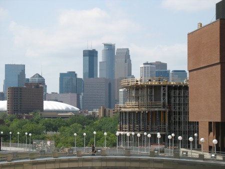
IMG_4499

Minneapolis’ IDS Center, reflecting the Wells Fargo Center.
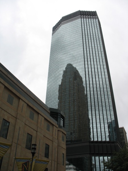
IMG_4450

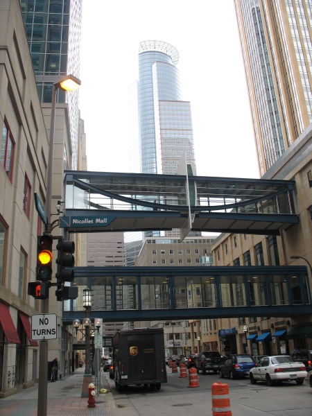
The third of Minneapolis’ big three skyscrapers is 225 South Sixth, seen here with a couple of Minneapolis’ infamous skyways in the foreground:
IMG_4448

Skyways: They are perhaps the single most identifiable thing about downtown Minneapolis.  The city boasts of the largest such network in the US.

St. Thomas University (which has business and law programs downtown) has a nice map of the skyway system, showing what a rats nest it can become as you navigate the 2nd floor of these buildings:

Minneapolitans love their skyways.  Growing up, they were just a fact of life.  It was only until I really got to visit other cities without them that I realized their detrimental impact on streetlife and the urban streetscape of downtown.  Minneapolis, however, almost seems to embrace it:

Seem a little quiet on the street? Minneapolis and Saint Paul are both home to a unique system of glass “tunnels” located one story above ground. We call them skyways–you can just call them convenient. Downtown Minneapolis’ 8-mile system and downtown Saint Paul’s 5-mile system will get you almost anywhere in climate-controlled bliss.

Ditch the coat in the hotel room and go exploring in this lively thoroughfare filled with specialty shops, restaurants, services, and, yes, even an annual golf tournament

“Where are all the people?” you ask. Look up. You may be missing something.

“Climate-controlled bliss” might be overselling it a bit.  The skyways are all located on private property.  This isn’t an issue on weekdays when things are busy, but on weekends, some all-office buildings will close up shop and skyway walkers will suddenly encounter a dead end.  Furthermore, as the Minneapolis booster piece indicates, there’s lots of service oriented retail on the skyway level – sandwich shops, dry cleaners, bank branches, etc – all sorts of things you’ll find in downtown DC, as well.  Except that they’re largely inaccessible outside of the normal working hours.

Worst of all, opportunities to connect between the street and the skyway level are few and far between, and most of them are in building lobbies which are subject to private control.  The result is a confusing network that only the experienced can navigate well.  The comparison to habitrails isn’t all that far off base – being back in the system for the first time in a few years, I felt like a lab rat running through a scientist’s maze looking for a bit of cheese.

Ascending into the system in the lobby of one of Target’s many downtown buildings shows some of the limits to the system.  During my last trip to Minneapolis, I tried to enter the skyway system at this same point – but since it was a weekend, the door was locked.  No dice.

IMG_4456

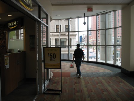
On the second level, you’ll find all sorts of retail options.  Here, as you traverse along the perimeter of a building’s second floor, you can also do all your banking at the same time:
IMG_4457

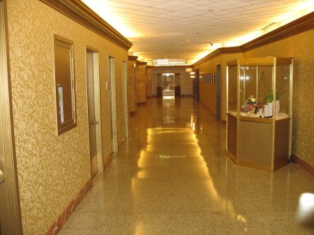
It’s carpeted and climate controlled.  The newer buildings downtown, built after the system took root, actively design for them.  They can be very mall like, where building lobbies help provide vertical circulation between levels.  This still doesn’t solve programmatic issues such as the locked doors on weekends (as that Target building is only a few years old), but it helps.  Older buildings have carved corridors out of second floor space, lack retail options, and can be extremely confusing to navigate:
IMG_4459

Somewhere in here I encoutered a dead end where my only option was to enter the parking garage and take a staircase down to the sidewalk level.  Likewise, there are plenty of areas where your directionality is challenged – to go north, you actually have to head east and then north.  It’s a system that favors the experienced.

Skyways can be a touchy subject for Minneapolitans.  Any time an outsider criticizes the system, they usually get lambasted as ignorant of the peculiarities of urbanism in northern climes.  One local critic is Steve Berg, a longtime writer and critic in the Twin Cities.  Berg compiled opinions of various urbanists on the skyway system, and the results weren’t exactly complimentary:

When two of the world’s top urban designers drop in for a visit and come away with the impression that your city — in this case Minneapolis — is a relic of the 1970s, ill-equipped to thrive and compete in a new century, and that its only hope is to tear down its skyways, well, that gets your attention.

“I feel sorry for Minneapolis,” said Jan Gehl, the celebrated Danish architect whose work around the world has linked the rising importance of good public spaces to a city’s success.

Thirty years ago, Minneapolis was thought to be a leader among winter cities. But taking people off the streets and putting them upstairs, “under glass,” hasn’t worked in Minneapolis or anywhere else, Gehl said, to the point that Minneapolis is no longer “up to the beat of the world-class cities of the 21st century.”

Gehl and Gil Penalosa continue:

The problem, Gehl explained, is that skyways violate the first law of successful city-building: keeping people together in a critical mass. Minneapolis’ skyways — as with similar pedestrian bridge or tunnel systems in Calgary, Toronto and elsewhere — disperse people over different levels at different times. On weekdays, skyways bustle and shops flourish for a few hours a day. But at night and on weekends, people are thrown out onto barren and neglected public sidewalks. A social hierarchy develops: the wealthier classes in private spaces on weekdays; poorer people out in public spaces at all hours. That’s not a winning formula, Gehl said. It’s bad for retail business, bad for culture, bad for civic life.

The impression given, said Penalosa, is of a fearful city crouching inward against a hostile climate and a hostile world. That’s not the kind of optimistic city that most people — especially young people — are looking for, he said. Repeating the phrases of economist Richard Florida, Penalosa said that if a city doesn’t present itself as vital at street level, then talented people won’t choose to live there, especially when they can live in Chicago or Seattle or anywhere they like. And if talent isn’t attracted or drifts away, then the quality of a city suffers.

What’s remarkable to me about Minneapolis isn’t that the skyways are bland, but that the city is as successful as it is in spite of the extensive skyway network.  The elements are all there, but they haven’t quite been tied together in the way that makes urban areas great places.  Indeed, some of Minneapolis’ best public urban spaces are places the skyways bypassed – the Warehouse District, Uptown, and others.  Still, the challenges that these skyways present to Minneapolis now, as it sits on the cusp of providing an even better urban experience, should be fair warning to other cities about the road not to take.

Minneapolis – Transit plans

A few more items from my trip to Minneapolis. The Twin Cities have some big plans for transit improvements.

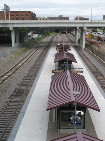
Under construction now is the Northstar Commuter Rail line, as well as the concurrent 2-block extension of the Hiawatha LRT to meet the commuter rail station.   The new station would be a potential hub of multiple light rail lines, as well as the terminus of several commuter rail lines and even intercity high speed rail.  Lofty ambitions, to be sure.

However, at present, it isn’t exactly the second coming of Union Station:

IMG_4476

One platform, two tracks (the third track on the far left is for through freight).  This picture was taken from the 5th Avenue bridge.  The area with the commuter rail platform is in an old rail yard substantially sunken beneath the usual grade for the rest of the area.  All of the cross streets in the area traverse the ditch on viaducts.

IMG_4475

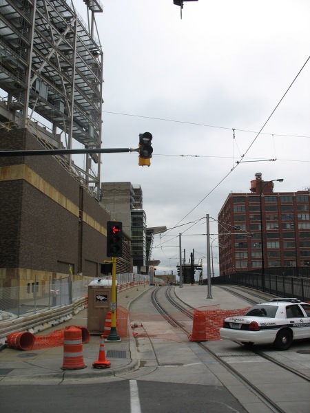
Immediately above the commuter rail platform is the new Ballpark station (that’s Target Field under construction in the background).  The Ballpark will feature vertical circulation for passengers transferring between commuter rail and light rail. The extension of the tracks (as well as the commuter rail) should be operational soon, with the ballpark to open next season.

IMG_4471

Right now, only the Hiawatha Line uses these LRT tracks.  Soon, the Central Corridor will join them, offering LRT service to the University of Minnesota and downtown St. Paul.  The next corridor under consideration will be the Southwest Corridor, extending from downtown Minneapolis to suburban Eden Prairie.

Both the Hiawatha and Central lines serve some prominent employment centers, as well as relatively dense neighborhoods and industrial space in need of redevelopment.  The Hiawatha line connects downtown Minneapolis with the airport and the Mall of America.  The Central corridor will extend between the two downtowns, serving the University of Minnesota.

The Southwest line, however, could potentially miss some of the densest, most vibrant areas of Minneapolis in favor of a cheaper alternative routing.  Yonah Freemark analyzes the situation:

After years of study, Minneapolis is almost ready to submit its locally preferred alternative (LPA) corridor to the Federal Transit Administration, which will distribute up to 60% of total funds to the project through the New Starts major capital grant program. In order to receive money from Washington, Metro will have to show that the proposed route meets national cost-effectiveness guidelines, which are stringent enough to sieve out a large percentage of proposed new transit lines.

This requirement puts elected officials in a quandary: should they work to build the most effective transit network possible, or should they limit their ambitions for fear that the federal government will rule out any funding at all?

Effectively, this is where Minneapolis finds itself, and the region is coming dangerously close to eliminating its best route option because of cost-effectiveness concerns. Of the three routes being considered for the Southwest Transitway’s alignment, one (#1A) has been dismissed by suburban officials because it won’t serve the city of Eden Prairie as effectively as the others, even though it would be cheaper to build. Another (#3C) is too expensive because it would require a tunnel under a section of Nicollet Avenue, but it would serve the city of Minneapolis best because it would provide several stations in the dense and active Uptown district. 3C would operate on the Midtown Greenway parallel to Lake Street in that section of the city. The last (#3A) is the only route, according to local planners, that could meet federal cost guidelines — but its effect on the commutes of people who live in Minneapolis would be marginal. 3A would skim the side of the Kenilworth trail and lounge the edge of two lakes, running through neighborhoods of single-family housing.

Yonah created a series of maps showing how the FTA’s cost-effectiveness numbers will likely lead to an inferior project overall.  One picture really shows how absurd the decision might be in deciding the two alignments to enter downtown Minneapolis:

Minneapolis has some promising long term transit plans, but I can’t think of a better example to showcase how misguided the FTA’s cost-effectiveness guidelines are if they favor the green line instead of the blue line on that map.

Space on our streets

I’ve read several interesting posts in the past few days on how we allocate space on our streets, and the implications of those decisions for public space, transportation, and congestion.  This hearkens back to discussions of older urban designs, where streets were laid out as public spaces, not delineated into auto lanes, sidewalks, medians, and the like.

Matt Yglesias: Why compartmentalize street space in the first place?

Whenever people start complaining about urban cyclists not following traffic rules, the typical response is to say that cyclists need more dedicated space on the road rather than awkwardly being shoved into street traffic.

But when I think about this, I’m always reminded of the fact that arguably we need fewer traffic rules. The basic idea of traffic rules—separated uses, painted lane markers, giant signs, etc.—is to make it safe for the drivers of cars to drive their cars very quickly. That’s an okay design principle for a highway, but its nearly-universal adoption as a design principle for urban roadways is arguably very misguided. If it were up to me, more city streets would follow Hans Monderman’s shared space principles and just be undifferentiated stretch on which cars, bikes, mopeds, pedestrians, etc. are all free to travel. The over-arching “rule” would be “don’t collide with anyone.”

Ryan Avent: Make better use of the road.

Because, you know, there were roads before there were cars. In Washington, for instance, Pierre L’Enfant set out an entire street system for the capital, despite the fact that there would be no cars at all using those streets for over a century. None! And New York and Boston, and London and Paris also had tons of streets, as far as I can tell, before a motor vehicle ever puttered into those cities.Meanwhile, I’m not suggesting that pedestrians and cyclists “unite against cars.” I’m suggesting merely that the way we currently use city streets gives too much deference to drivers. There’s nothing antagonistic here; I’m simply suggesting that current policy doesn’t actually use street space all that well.

Amongst all of that road space dedicated to cars, a couple of posts (including a throwback) about the nature of congestion within that space.

Freakonomics: More road choice slows everyone down.

Two physicists and a computer scientist used Google maps to study traffic in Boston, London, and New York, and found that when people use real-time driving maps to try to pick the fastest routes, traffic slows down.

And, the throwback – the physics of gridlock.

World Streets: What causes traffic jams?  The answer may be nothing at all.

But the physicists added some terms to the equations to take the differences into account, and the overall description of traffic as a flowing gas has proved to be a very good one. The moving-gas model of traffic reproduces many phenomena seen in real-world traffic. When a flowing gas encounters a bottleneck, for example, it becomes compressed as the molecules suddenly crowd together — and that compression travels back through the stream of oncoming gas as a shock wave. That is precisely analogous to the well-known slowing and queuing of cars behind a traffic bottleneck: as cars slow at the obstruction, cars behind them slow too, which causes a wave of stop-and-go movement to be transmitted “upstream” along the highway.

The eeriest thing that came out of these equations, however, was the implication that traffic congestion can arise completely spontaneously under certain circumstances. No bottlenecks or other external causes are necessary. Traffic can be flowing freely along, at a density still well below what the road can handle, and then suddenly gel into a slow-moving ooze. Under the right conditions a small, brief, and local fluctuation in the speed or spacing of cars — the sort of fluctuation that happens all the time just by chance on a busy highway — is all it takes to trigger a system-wide breakdown that persists for hours after the blip that triggered it is gone. In fact, the Germans’ analysis suggested, such spontaneous breakdowns in traffic flow probably occur quite frequently on highways.

Basically, we’re talking about Chaos Theory applied to traffic movements.  It all stems from the fact that you’re dealing with thousands of individual actors (drivers) within a complex system.

If breakdowns in flow can result from such small and random fluctuations, then the world is a very different place from the one that most traffic engineers are accustomed to. The very notion of maximum capacity for a highway is called into question, because even at traffic densities well below what a highway is designed to handle, jams can spontaneously arise. “If this flow breakdown can take place just anywhere,” says James Banks, a professor of civil and environmental engineering at San Deigo State University, “then we’re in trouble, because there’s a lot more potential for congested traffic than we thought was the case. And it makes a control strategy much more difficult.”

Some of us would argue that the world is already a different place from the one the traffic engineers like to envision (wink wink).  It also highlights the capacity advantages of mass transit in urban areas.  Looking back at the hypothetical Frumination post on NYC without the subway (mentioned here), the point becomes more clear.  Under the assumption that each train is carrying over 1,000 people (and assuming, for the sake of argument, that each one of those would otherwise be driving a single occupant vehicle), the advantages of the subway become clear.  Not only is it more spatially efficient, but you’re dealing with one actor and one vehicle (the subway train and the operator) rather than 1,000.

Furthermore, getting into the earlier discussion of traffic rules, individual drivers tend to emphasize different points of the law.  Each person has a different driving style in how they accelerate, brake, when they change lanes, etc.  Subway trains do not have that freedom, the details of their operations are far more controlled, and thus far more predictable.

The freedom that many people (like Gary Imhoff) associate with the automobile is also the basis for massive congestion.  The car giveth, and the car taketh away.  This fundamental reality often escapes folks arguing for more auto-based infrastructure.  In many ways, it’s a tragedy of the commons – each additional car in traffic makes sense for that self-interested driver, but the overall impact is bad for everyone.