A few more items from my trip to Minneapolis. The Twin Cities have some big plans for transit improvements.
Under construction now is the Northstar Commuter Rail line, as well as the concurrent 2-block extension of the Hiawatha LRT to meet the commuter rail station. The new station would be a potential hub of multiple light rail lines, as well as the terminus of several commuter rail lines and even intercity high speed rail. Lofty ambitions, to be sure.
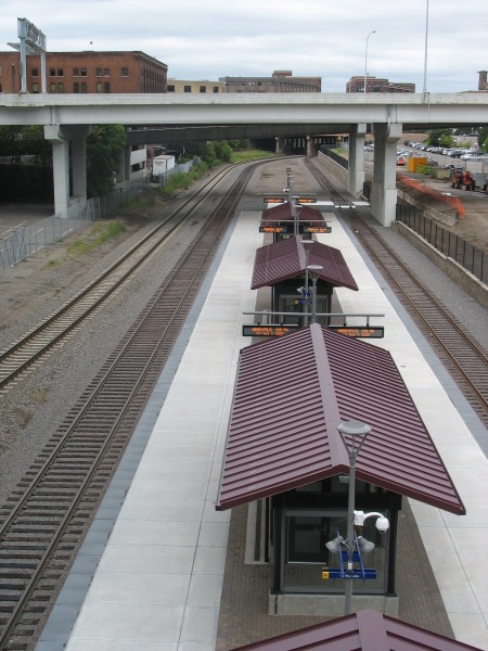
However, at present, it isn’t exactly the second coming of Union Station:

One platform, two tracks (the third track on the far left is for through freight). This picture was taken from the 5th Avenue bridge. The area with the commuter rail platform is in an old rail yard substantially sunken beneath the usual grade for the rest of the area. All of the cross streets in the area traverse the ditch on viaducts.

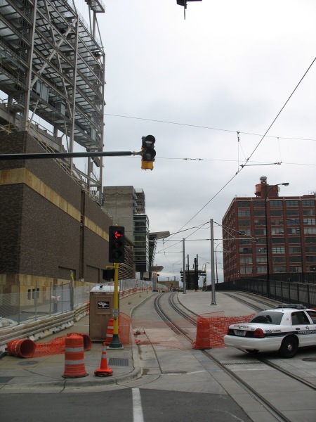
Immediately above the commuter rail platform is the new Ballpark station (that’s Target Field under construction in the background). The Ballpark will feature vertical circulation for passengers transferring between commuter rail and light rail. The extension of the tracks (as well as the commuter rail) should be operational soon, with the ballpark to open next season.

Right now, only the Hiawatha Line uses these LRT tracks. Soon, the Central Corridor will join them, offering LRT service to the University of Minnesota and downtown St. Paul. The next corridor under consideration will be the Southwest Corridor, extending from downtown Minneapolis to suburban Eden Prairie.
Both the Hiawatha and Central lines serve some prominent employment centers, as well as relatively dense neighborhoods and industrial space in need of redevelopment. The Hiawatha line connects downtown Minneapolis with the airport and the Mall of America. The Central corridor will extend between the two downtowns, serving the University of Minnesota.
The Southwest line, however, could potentially miss some of the densest, most vibrant areas of Minneapolis in favor of a cheaper alternative routing. Yonah Freemark analyzes the situation:
After years of study, Minneapolis is almost ready to submit its locally preferred alternative (LPA) corridor to the Federal Transit Administration, which will distribute up to 60% of total funds to the project through the New Starts major capital grant program. In order to receive money from Washington, Metro will have to show that the proposed route meets national cost-effectiveness guidelines, which are stringent enough to sieve out a large percentage of proposed new transit lines.
This requirement puts elected officials in a quandary: should they work to build the most effective transit network possible, or should they limit their ambitions for fear that the federal government will rule out any funding at all?
Effectively, this is where Minneapolis finds itself, and the region is coming dangerously close to eliminating its best route option because of cost-effectiveness concerns. Of the three routes being considered for the Southwest Transitway’s alignment, one (#1A) has been dismissed by suburban officials because it won’t serve the city of Eden Prairie as effectively as the others, even though it would be cheaper to build. Another (#3C) is too expensive because it would require a tunnel under a section of Nicollet Avenue, but it would serve the city of Minneapolis best because it would provide several stations in the dense and active Uptown district. 3C would operate on the Midtown Greenway parallel to Lake Street in that section of the city. The last (#3A) is the only route, according to local planners, that could meet federal cost guidelines — but its effect on the commutes of people who live in Minneapolis would be marginal. 3A would skim the side of the Kenilworth trail and lounge the edge of two lakes, running through neighborhoods of single-family housing.
Yonah created a series of maps showing how the FTA’s cost-effectiveness numbers will likely lead to an inferior project overall. One picture really shows how absurd the decision might be in deciding the two alignments to enter downtown Minneapolis:
Minneapolis has some promising long term transit plans, but I can’t think of a better example to showcase how misguided the FTA’s cost-effectiveness guidelines are if they favor the green line instead of the blue line on that map.


Alex, appreciate the posts, and as a Minnesotan (St. Paul) living in DC I share most of your opinions.
But I think transportpolitic and you might be missing the point on the rail alignment question here. While I agree the Kenilworth route seems less desirable, it will attract more new transit riders, and free up hundreds of millions of dollars for other transit projects. Keep in mind there are plans already under way (and the county has dedicated some funding) for streetcars down Hennepin, Nicollet, and between Hiawatha and Lake Calhoun along the midtown greenway.
The midtown greenway coalition is strongly opposed to light rail along the route, which carries thousands of new bicycle commuters every day (ok, it isn’t quite 1,000 yet in January, but it is hundreds). The light rail line would severely restrict the bicycle right of way along the greenway, and more importantly wouldn’t provide a link through all of midtown (and to the Hiawatha LRT), which the proposed streetcar line would.
Just my two-cents,
Streetcar Plans:
http://www.ci.minneapolis.mn.us/public-works/trans-plan/StreetcarStudy.asp
I don’t think it will attract more riders. I think the FTA’s estimates say that, but their estimates also say that the two routes would have equal ridership, which doesn’t pass the smell test for me. The FTA also doesn’t have the greatest track record with their ridership estimates – almost all of the recently added light rail lines in the US have blown their long term estimates (year N+15 or +20) out of the water in 2 or 3 years.
Streetcars are great, but as I’ve discussed here before, their main benefits are in accessibility and not mobility. The purpose of rapid transit is to increase both, and Uptown is a worthy destination.
As for the greenway, it’s a tremendous asset for bikers, but they can still be accommodated with light rail in the trench as well. That trench is far too valuable to be used just for biking. Biking and transit can and should co-exist there.
Pingback: Minneapolis – Skyscrapers and Skyways « city block
Pingback: Midwest Miscellany | Michigan Real Estate
Question — does the line move more local traffic, or more express traffic?
There’s little doubt that the direct, low density route will move people from the southwest suburbs to Minneapolis at a very high rate of speed, which will help commuter ridership. But the high density route will generate much more local and off-peak traffic and probably require a lower operating subsidy assuming we’re talking light rail on both routes. My sense is that Minneapolis eventually needs both lines, but that the Uptown route is more appropriately served by light rail and the direct express route is more appropriately served by a half hourly or four times an hour commuter rail service.
I agree with your conclusion, DBX – but I don’t think the FTA’s ridership estimates properly capture that reality…
Pingback: Around the horn – City Block